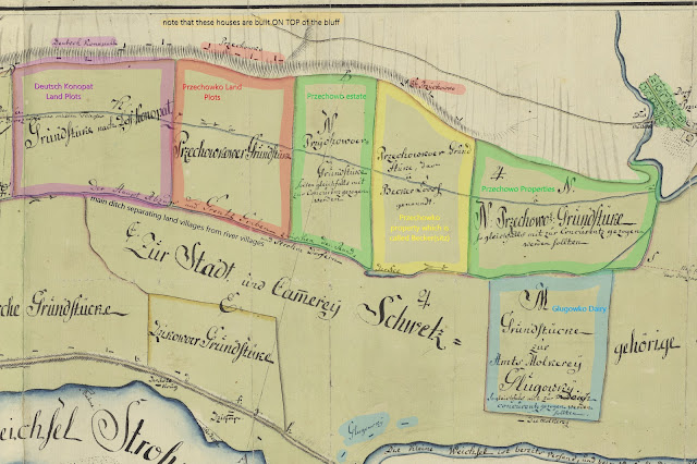
From the Geheimes Staatarchiv in Berlin, we have XI_HA_PKM_G_Nr_1622_0001, Plan of the Little Schwetz or Niedwitz Lowland, 7 May , 1791; a map of the left bank of the Vistula river in the vicinity of Świecie, Poland, from the year 1791. This may be the most detailed map we have from the Mennonite era for the village of Przechówko.
The map shows the village conglomeration from Świecie, in the northeast, to Chrystkowo in the southwest; between them, in two rows, Kosowo, Niedźwiedź, Dzikowo, Głogówko, and Gruczno, Dworzysko, Deutsch Konopat, Przechówko, Beckersitz, and Przechowo. This map helps to explain a lot of questions that have arisen regarding the geography of the Przechówko area during the Mennonite-era.
This cropping, annotated with my notes, shows some explanation:
In purple at left (west) is Deutsch Konopat (today = Wielki Konopat), then "Przechowkower Grundstüke" or Przechowko Land Plots, in red. In green are plots of land belonging to Przechowo (the Przechowo Vorwerk). Next is Beckersitz (in yellow), "Przechowko property which is called BeckerLoos". Then again in green, Przechowo properties. In blue is the Glugowko dairy. Separating the two rows, north from south, is a ditch or canal, which still exists today.
Several points to note:
There has been some confusion about the names Przechowko and Przechowo. Przechowo is the larger town mostly on the north side of the Wda River. Przechowko is actually named after Przechowo; Przechowko is a diminutive of Przechowo, literally meaning small Przechowo. In German sometimes we see Przechowko named as Klein Przechowo (see 1773 Prussian census). We also know that Przechowko villagers sometimes leased land known as the Przechowo Vorwerk - Przechowo manor land. This map identifies the location of that land as immediately to the east of Przechowko. So, this is all something very confusing for modern Americans, but we have 3 pieces of land here: Przechowko, the Przechowo Vorwerk, and Przechowo itself. Each of these "sections" of land were distinct and different.
And to add to confusion is Beckersitz (in Polish sometimes we find it listed as Piekary/Bekierzyc). This is a piece of land, according to this map, that is property of the village of Przechowko. And with the 1773 census, we have corroboration that Beckersitz is a separate property of land owned or leased by the village of Przechowko. So Beckersitz residents were also Przechowko residents, but not really.
At the top of the map we have the row of bluffs and the road which ran from Przechowo to Niewieścin, which is basically the Bydgoska Road, then the E261 today. Note that houses are built on top of the bluff, when in reality they were below the bluff.
This cropping of 1796 Schroetter map (SBB_IIIC_Kart_N 1020_Blatt 119 Berlin Geheimes Staatarchiv) shows the area at almost the same time period with a more accurate geographical perspective. Note here that Przechowko (circled red) shows 12 properties, Deutsch Konopatt, 24, Bekersitz, 4. Note here also that houses are marked, sitting below the bluff, which more reflects reality than the other map above.


No comments:
Post a Comment