Tuesday, April 23, 2013

The Village of Leeleva


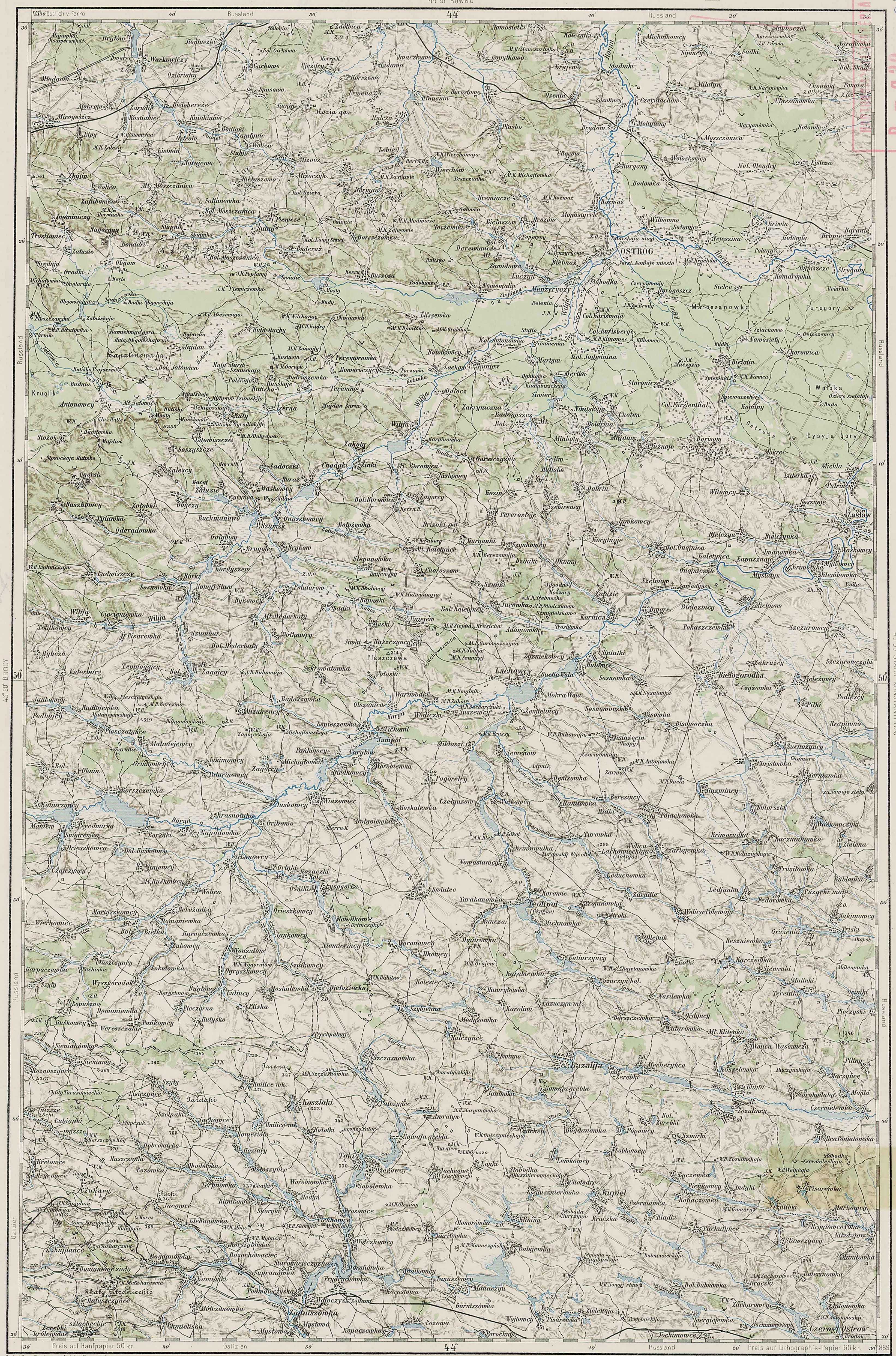
The village of Leeleva was located on the main road that ran from Kamenka to Pluzhnoe.  Travelling generally south-southeast, one would have passed out of Kamenka, through the forest, over a couple large hills and then downhill into Dertka.  From there, the road went again straight south, over a large hill, and down into Siver.  This stretch of road passed between two small lakes which were drained probably in the 1940s.  Leeleva lay just south of Siver, at an elevation of about 210 meters.  The main road through the village went generally uphill and continued on to Miakoty, less than a mile to the south, which is at an elevation of about 220 meters.  This road continued on to Pluzhnoe, another 3 miles farther east. Two hills rise just to the south of the houses of Leeleva, the taller of which rises over 240 meters.  The distance by road from Kamenka to Leeleva was almost 4 miles and in the 19th Century would have been almost entirely through forest.  The main road through Leeleva ran northwest to southeast.  Another east-west road ran through the village; west to Mala (small) Radogosch and east to Balyary.  Some researchers seem to have combined Leeleva with Siver; this appears to be incorrect.  Based on current satellite views as well as old Polish, Russian and Austrian maps, Siver (today known as Syvir; Ukr: Сйвір) is a separate village immediately adjacent to Leeleva to the northwest.  

German: Fuerstendorf or Fürstendorf (Russian: Фюрштендорф; Ukrainian: Фюрштендорф),

Russian: Lesna: (Ru: Лесна or Лѣснa; Ukr: Lisna, Лісна; Polish: Lisna),

Also known as Lesnaja (Ru: Лѣсная or Лесная; Ukr: Лiсня), or Liesnaja or Lesnaya,

Leeleva (Ru: Лелева; Ukr: Лелевой) or Lileva or Lilewa,

Also known as Lebwa, Nikitskaya or Nikitska. 

There may be confusion about the name of this village as lesna/lisna is a term for “forest” in Russian and Ukrainian.  Further, the forest south of Ostrog may have been named Nikitskaya Forest at some point in time.  German-speaking cartographers of the late 19th Century may have confused the village and the forest and mistakenly labeled the village Nikitskaya instead of the forest (Jewish sources name a forest near Ostrog Nikitsky or Nikitin).

Established as early as 1765 by Ukrainians or Poles, the earliest appearance of the village in Mennonite sources (under its German name: Fuerstendorf) is 1874.   My Ratzlaff Family tradition suggests that Ratzlaffs lived in this village, which they called Leeleva, by 1869. 

This village was the last home of the Mennonite colonists in the Ostrog area.  As the majority of Mennonites left the other nearby villages in the last quarter of the 18th Century, those who stayed behind consolidated in Leeleva.  German Lutheran colonists began moving into the village as the Mennonites left for America.  The Lutheran Church fell under the authority of the Rivne Lutheran Parish.  Early 20th century Mennonite sources state the Mennonite Church in Leeleva was affiliated with the (Neu) Alexanderwohl Mennonite congregation, which suggests a connection between this village and Polish (Royal Prussian) Przechowka.  A 1930s map of Lutheran Leeleva indicates that the area to the east of the village was used as communal meadow.  A road to the west of the village, Teppergasse, seems to indicate the presence of a tavern or a brewery/distillery of some sort while the road to the east, Entenquak, suggests a duckfarm or something similar.  The Lutheran map goes on to indicate the cemetery on the west side of the road, mid-way through the village, with the church directly across the street to the east.  My own Ratzlaff Family tradition indicates the houses in the village were offset one from another in order to prevent fires spreading from one yard to another.

A 1906 census of the region included a village by the name of Lesnaya (Лѣсня) as well as one by the name of Leleva (Лелева).  The population of Lesnaya was listed as 267 in 52 households and Leleva as 244 in 26 households.  Both were listed as falling under the jurisdiction of the 3rd police precinct of Ostrog County.  At this point I have no idea why 2 villages were listed in this census.

The German inhabitants of the village were known as skilled farmers and blacksmiths.  From at least 1889, as indicated by an Austrian map of that date, these farmers may have taken their grain to be milled at a watermill located at nearby Siver.  If, that is, the landlords of the tenant farmers allowed it.  After the Russian Revolution, the council of the village continued to use the German language until the 1930s, but most Germans were evicted by the year 1936 (30 German and Polish families were evicted at this time, perhaps to Kazakhstan).  Leeleva was placed by the Soviets in the collective which included Dertka, Siver, Jadvanin, and Mikhaylovka. 

In 2001, the population of the village was 97 people.  The village today is in the Ukrainian Khmelnytsky Oblast or Province (Хмельницька область), Izyaslav Raion or District (Ізяславському районі), Dertkivska Village Rada or Council (Дертківська сільська рада).


Green Ratzlaff Book

Abe Unruh, The Helpless Poles

Lutheran Lesnaya map

Mennonite Leeleva map

Friday, April 19, 2013

The Villages of Mikhaylovka and Stanislavka


The village of Mikhaylovka sat less than a mile southeast of Jadwinin (almost 2 miles by road via Klinowiec).  In the 19th Century, one would have left Jadwinin to the east and gone about ½ mile to Klinowiec (also known as Borisovskoye-Klinovets) which sat at the base of a small hill.  The road went around the hill and turned south through the forest and entered Mikhaylovka in about a mile.  The village was situated in an east-west orientation at an elevation of about 210 meters; rising slightly in the middle and downhill on both ends.

Known as Mikhaylovka in Russian (Михайловка or Михайлівка; Ukrainian: Mykhailivka, Миха́йлівка; Polish: Mykhajlivka; German: Michajlowka, Michailowka), the village was founded at an unknown date after 1874 by Germans, either Mennonites or Lutherans, on a small stream called the Dreloh (now called Synytseva).  The German inhabitants specialized in agriculture and grew rye, potatoes, barley, millet and buckwheat.  During the 19th Century, grain was transported to the mill at Ostrog for harvesting.  After the Polish War in 1921, grain was taken to mill in Slavuta as Ostrog became a Polish town.  Villagers during this time also raised some cows and pigs as well.

By the late 1800s, Mikhaylovka consisted of 35 houses with some 241 inhabitants.  Houses were built with pine boards which were joined at the corners with “fishtail” joints.  Wealthy inhabitants bought cut foundation stones from Kamenka to create a foundation and floor for their homes.  Less wealthy folks had to make due with foundation stones only at the corners or under door jambs of their houses.  Most houses had large stoves, built with raw bricks covered with plaster.  Bricks were made from clay from nearby clay deposits.  A house dating from the late 1880s reportedly still stands in the village today.  Grain was usually threshed with flails, while a few more wealthy farmers could afford a horsedrawn threshing wheel.  Later in the 19th Century, grain was also taken to mills that had been erected nearby in the villages of Nitishin, Bolotin, Kamenka, Dertka, or Balyary.  The villagers in Mikhaylovka attempted to build a mill, but unfortunately were not successful.

In 1906 the population of the village was 264 people living in 48 households.  As with the other nearby villages, Mikhaylovka underwent forced collectivization during the 1920s and in 1936 was placed into a collective with the other remaining German villages of Leeleva (Lesna) and Karolswalde.  Later the collective removed Karolswalde and added Jadwanin and Dertka.  Some Poles and Czechs moved into the village during this time.  During collectivization, the Mikhaylovka wooden church was closed down by the Soviets and many Germans were evicted to Siberia.  In 1939 German villagers from nearby Stanislovka were relocated to Mikhaylovka.  Then in 1942, any remaining Germans were relocated to a village near Yuvkivtsi (about 8.5 miles to the south) forming the village of Zonental (Sun Valley).  The primary school in the village was also closed by the Soviets at some point by the 1960s.

Since Mikhaylovka was originally a German village, the cemetery held only Germans.  Later, as Poles or Czechs moved into the village, they had to be buried elsewhere, such as Jadwinin or Kunev.  After WWII, with the eviction of the Germans, the village was populated predominantly by descendents of Poles.  However, a woman named Tatiana Nightengale, perhaps a descendent of the German Mennonites, was still listed as a school teacher in the village in the mid 1940s.

Today, the results of the collapse of the USSR and the rise of a capitalist economy have almost destroyed the village, leaving it populated mostly by pensioners; the population in 2001 was only 58 people.  The village is presently in the Ukrainian Khmelnytsky Oblast or Province (Хмельницька область), Izyaslav Raion or District (Ізяславському районі), Dertkivska Village Rada or Council (Дертківська сільська рада).


http://istvolyn.info/index.php?option=com_content&task=view&id=926&Itemid=5


The German village of Stanislavka (Russian: Станіславка; Ukrainian: Станіславка; Stanislavka; also known as Stanisovka) sat just to the southwest of Mikhaylovka.  The village was situated in a north-south orientation along the road running from Mikhaylovka to Balyary and Khoten.  Leaving Mikhaylovka to the west, one would have turned south after about ¼ mile.  The road gently curved uphill to the east and in slightly less than a mile, one would have reached Stanislavka.

Today the village of Stanislavka no longer exists.  Along with Mikhaylovka, it was established after 1874 by German Mennonites or Lutherans.  Austrian maps from the late 1880s show neither Mikhaylovka nor Stanislavka, but Polish maps from several years later do indeed show both villages.  In 1906 the village had a population of 461 people in 46 households.  However, the village disappeared soon after 1939 when the Soviets moved the German population to nearby Mikhaylovka.  The site of the village was at approximately 50°13’55.4”N, 26°30’22.7”E.


Thursday, April 18, 2013

FM Goossen Family

One of the most interesting things about posting a family history blog is meeting distant family members who are also interested in the family history.  I've been contacted by numerous Ratzlaffs, to whom many I can easily trace my relationship.

Recently I was contacted by a grand-daughter of Florentine (Ratzlaff) Goossen.  Florentine was born in Leeleva, Volhynia, in 1904, to Andreas and Susanna (Wedel) Ratzlaff and was an older sister to my grandfather, Albert Ratzlaff.  Florentine married John D Goossen, son of Franz Goossen (FM for short) of Marion County, KS, in 1924 at the Alexanderwohl Mennonite Church and the family made their home a mile south and about 5 miles east of Hillsboro, in Wilson Township.  Florentine and John had 7 children who were cousins to my father, Norman Ratzlaff, and I think my Dad palled around with these Goossen boys quite a bit when they were young.  Dad has told me numerous stories about this family's adventures; most of the sons were involved with motorcycles, airplanes, etc, and as I understand it, one of them even busied himself by prospecting for gold in the mountains of the western United States!  Several of the boys moved to Farmington, New Mexico, when they grew up.

The Goossen family was among the Russian Mennonites emigrating to the US from the Molotschna Colony.  The Goossens traveled to the United States aboard the SS Vaderland in 1877 (the same steamship that brought my great great great grandmother Anna (Koehn) Ratzlaff to America in 1874 as well as my great great grandfather Heinrich Wiens in 1876).  Much more can be learned about the Franz Goossen Family at http://www.fmgoossenfamily.com/WP/.


The Village of Jadwinin


The Mennonite villages of Stanislavka, Leeleva, Fuerstenthal, Mikailovka and Jadwinin were all included in (Pluzhanskoy) in 1906.  Of these, Jadwinin was the closest to the primary Mennonite village, Karolswalde.  Passing south out of Karolswalde, the road to Jadwinin went downhill just a touch and then uphill through the forest for about 1.5 miles and entered Jadwinin from the west.  Jadwinin was situated on an east-west orientation at an elevation of around 200 meters.  A large hill rising almost 20 meters sits directly behind the village, and more hills rise to the east.  Houses in Jadwinin were built on the north side of the road and the long, thin plots stretched out to the north, the Ritschke River (which was really just a small stream) providing water to each plot (this was the same stream which flowed by Karolswalde).

In Russian, the village was known as Yadvonino (Ядвоніно) or Yadvigin (Ядвигинъ); Yadvonine (Ядвоніне) or Yadvigin (Ядвігін') in Ukrainian; Jadwinina or Jadwinin in German and the spellings Yadvonine and Jadweninne can be found elsewhere.  According to Russian/Ukrainian sources, Jadwinin was established by 1868 by Czech settlers.  However, according to the Tobias Unruh baptism record, German Mennonites were living in the village and being baptized there by 1854, so obviously some discrepancy exists regarding the origin of the village.  Nevertheless, the Russian government did invite Czechs into Volhynia, enticing them with cheap land, just as they did for German Mennonites and Lutherans.  The Slavic Czech people were discriminated against in their native Austria-Hungary by the ruling Germans, so many were very willing to move into Volhynia, which had always been controlled by either Slavic Poles or Russians.  The Russian government gave many Czechs military exemption for 5 years, but prohibited them from being Roman Catholic, which most of them were in their native Austria-Hungary.  Thus, most Czechs in Volhynia became Russian Orthodox.  A wooden Russian Orthodox Church was built in 1913 near the crossroads of Jadwanin, Karolswalde, Kamenka and Mikailovka (possibly located at 50°14’47.6”N, 26°29’49.7”E or 50°14’51.5”N, 26°28’27.6”E).  The cemetery in Jadwinin was divided and had sections for Czechs, Ukrainians, Poles, and Germans.  Cemetaries in this area of Volhynia typically had separate sections for the various ethnic or religious groups.  The Czechs also built a primary school in Jadwinin in the early 1900s.  In late 19th Century there were 42 houses in the village with some 270 inhabitants.  By 1906 there were 44 households with 233 inhabitants.  The village was in the third Ostrog County Police precinct. 

Most houses in the village were combination type houses, connected to barns, and had thatched roofs, probably after the tradition of specific ethnicity of the home.  The Czech settlers generally did not raise crops, but kept animals instead, although some Czechs did keep an occasional rye field.  Czechs were generally more skilled at agriculture than were the Ukrainians, but not as skillful as the Germans.  Both Czechs and Germans kept horses and cows.  Milk from the cows was separated and taken to market in Ostrog until 1921.  After the Polish-Soviet War of 1921, diary goods were taken to the butter factory in Slavuta.  Other residents of Jawinin worked in forestry-related industries. 

By the late 19-teens, a temporary narrow-gauge railway was built and ran from Jadwinin to Krivin (via Bolotin), some 10-12 miles away, but this was dismantled by the mid-1920s.  Before collectivization, villagers had occupied themselves with agriculture in addition to weaving, shoe-making, carpentry and blacksmithing, but Stalin’s collectivization effort arrived in Jadwinin in 1933, consolidating the area’s agriculture as well as many other vocations.  The famine of 1932-33 which hit much of Ukraine hard, did not affect village directly. 

By 1935-36 most of the Germans and Poles had been evicted by the Soviets.  In 1938-39 work began on a nearby concrete wall as a line of defense against the Nazis (called the Line of Stalin).  The concrete was taken from the concrete factory in nearby Dertka.  Until the mid-1930s, the Czechs who remained in the area were able to retain some facets of their own culture, but the Soviets pressed hard to homogenize the culture.  In 1942, most of the remaining Germans in the area were relocated to a village near Yuvkivtsi, about 11 miles to the south.  The resulting empty houses were given over to Ukrainians. 

In 1944 there were 107 families living in the village and the collective which included Jadwinin kept a couple pigs, several lambs, and a cow or two.  The residents grew millet and barley and potatoes as well as apples, plums and cherries.  During the1940s the Soviet government charged exorbitant taxes on all products, making it difficult for the residents to retain any revenue.  Most remaining Czechs were evicted by 1947 and it was at this time that the village was renamed Novoselka (Russian: Новосёлка; Ukrainian: Novosilky, Новосі́лка).  The church was closed and dismantled soon afterward.  The school was also closed and children had to go to nearby Balyary, Kunev or Mikailovka for education.  In the early 1960s, the collective combined Jadwinin with Dertka and Mikailovka.  By mid the 1980s, only 12 houses remained and by in 2001 the population of the village had decreased to only 12 people.  Novosilky today is administratively part of the Ukrainian Khmelnytsky Province, Izyaslav District, Dertkivska Village Council.
Ukrainian Khmelnytsky Oblast or Province (Хмельницька область), Izyaslav Raion or District (Ізяславському районі), Dertkivska Village Rada or Council (Дертківська сільська рада)


Tobias Unruh Baptism Record

Wednesday, April 17, 2013

Pluzhnoe Township (Pluzhanskoy)


Pluzhnoe Township (Pluzhanskoy) in 1906 covered the central area of Ostrog County directly east of Kunevskoy.  This township included the Mennonite villages of Stanislavka, Leeleva, Fuerstenthal, Mikailovka and Jadwinin.

In total, Pluzhanskoy included 33 settlements or villages in 1906.  Boroisov (Borysow) was the largest village in the township with 550 households and a population of 2,899 people.  Pluzhnoe itself was the second largest village in the township.  Other important villages included Miakoty, Gnoynitsa (New Gnojnica) and Bolotin (Bialotyn).  Miakoty and Boroisov lie directly on either side of Pluzhnoe, forming a row of 3 large villages along the road to Zaslaw.  Bolotin, a few miles north of Pluznoe, sits on the ancient road which ran through the forest from Ostrog to Zaslaw.  Bolotin was an important center for ceramic and porcelain production.

The township was characterized by hilly land with increasing forest cover, and decreasing elevation, towards the north.  In most cases, villages were built in low clearings between hills, with roads running through the valleys.  The point of greatest elevation in the township was a hill standing between Pluzhnoe and Boroisov which stands at just over 290 meters.  Lowest points were in the northeast of the township near Dertka and Siver at points barely higher than 200 meters.

Here’s a full listing of the Pluzhanskoy villages in 1906.  Note that this listing includes a village named Lesnaya as well as one named Leleva.  I’ve always thought that Lesnaya and Leleva (Leeleva) were one and the same, but perhaps they weren’t.  Maps, however, do not indicate the presence of two villages.  Furthermore, the village of Balyary is missing from this listing.  On some maps, Balyary is listed as Khoten II, so perhaps the compilers of this list included the inhabitants of Balyary with those of Khoten.

Плужанской Pluzhanskoy
(Ukr: Плужанской)
Russian Ukrainian English (from Russian) Households Police Precinct Population nearest post office
1 Бороисовъ Бороісов' Boroisov 550 #3 2899 G. Ostrog
2 Плужное Плужне Pluzhnoe 434 #3 2302 G. Ostrog
3 Мякоты М'якоти Miakoty 329 #3 1767 G. Ostrog
4 Гнойница Гнойніца Gnoynitsa 191 #3 1010 G. Ostrog
5 Хотень Хотінь Khoten 220 #3 760 G. Ostrog
6 Болотинъ Болотін' Bolotin 75 #3 710 G. Ostrog
7 Бильчинъ Більчін' Bilchin 151 #3 643 G. Ostrog
8 Майданъ Майдан' Maydan 40 #3 565 G. Ostrog
9 Войтовцы Війтівці Voytovtsy 58 #3 502 G. Ostrog
10 Дертка Дертка Dertka 31 #3 464 G. Ostrog
11 Станиславовка Станіславівка Stanislavovka 46 #3 461 G. Ostrog
12 Сторониче Стороніче Storoniche 51 #3 323 G. Ostrog
13 Лѣсня Лiсня Lesnaya 52 #3 267 G. Ostrog
14 Михайлівка Міхайлівка Mykailivka 48 #3 264 G. Ostrog
15 Радогощъ-Малая Радогощ'-Мала Radogosch-Small 43 #3 237 G. Ostrog
16 Кустарная кустарна Kustarnya 42 #3 236 G. Ostrog
17 Ядвигинъ Ядвігін' Yadvigin 44 #3 233 G. Ostrog
18 Сиверъ Сівер' Siver 21 #3 214 G. Ostrog
19 Калетинцы Калетінци Kaletintsy 41 #3 184 G. Ostrog
20 Спивачекъ Співачек' Spivachek 10 #3 151 G. Ostrog
21 Лелева Лелевой Leleva 26 #3 144 G. Ostrog
22 Борисовскй-Клиновецъ Борисовський-Кліновец' Borisovskoye-Klinovets 6 #3 72 G. Ostrog
23 Спивакъ Співак' Spivak 18 #3 71 G. Ostrog
24 Мякотский-Клиновецъ Мякотскій-Кліновец' Myakotsky-Klinovets 12 #3 60 G. Ostrog
25 Бродокъ Бродок' Brodok 9 #3 54 G. Ostrog
26 Лысая-Гора Лиса-Гора Lysa Hora 2 #3 15 G. Ostrog
27 Пивнева-Гора Півнева-Гора Pivneva Hora 2 #3 10 G. Ostrog
28 Даньковка Даньківка Dankovka 1 #3 10 G. Ostrog
29 Кпани Кпані Kpani 2 #3 7 G. Ostrog
30 Лемеши Лемеші Lemeshi 2 #3 7 G. Ostrog
31 Забавка Забавка Zabavka 1 #3 7 G. Ostrog
32 Лиски Ліски Liski 1 #3 3 G. Ostrog
33 Нево Нево Nevo 1 #3 3 G. Ostrog
2,560 14,655


The Poles mapped Western Ukraine in the 1930s.  Taken from Polish maps from the late 20s to the early 30s, these were notable locations or services in Pluzhanskoy:

Post Office: Boroisov
Water mills: Dertka, Bolotin, Spivak, Khoten, Siver, Mala Radogosch (small), Gnoynitsa and Majdan
Windmill: Boroisov
Factory: Bolotin
Natural water spring: Pluzhnoe, Boroisov, Lysa Gora
Cemetery: Jadwinin (Yadvigin), Storoniche, Miakoty, Kaletintsy, Dertka, Lesnaya, Bilchin, Gnoynitsa
Gamekeeper’s lodges: Storoniche, Bolotin, Spivak, Kozaki, Boroisov, Lysa Gora
Colonies: Stanislavka, Mikailovka, Lesnaya, Kustarnya (Fuerstenthal)
Folwork: Khoten, Miakoty, Pluzhnoe, Voytovtsy, Bilchin, Lysa Gora
Futor: Spivak, Boroisov, Bilchin
Estates: Pluzhnoe, Gnoynitsa
Notable churches: Miakoty, Pluzhnoe, Boroisov, Gnoynitsa
Apaiary: Liski, Bilchin, Lysa Gora


The presence of apiaries in the southern areas of Pluzhanskoy is interesting.  An apiary is a place where beehives are kept, otherwise known as a bee-yard.   Known as a pasika (пасіка) in Ukrainian, an apiary would have been a fenced yard in which multiple beehives were kept and tended in order to harvest honey.  Ukraine has long cultivated a bee-keeping culture and even today ranks among the world’s leaders in honey production.  Here’s an old etching of a 19th Century Ukrainian apiary, perhaps similar to those located in Pluzhanskoy.


Monday, April 15, 2013

The Village of Pluzhnoe, seat of Pluzhnoe Township


In 1906, the Mennonite villages of Stanislavka, Leeleva, Fuerstenthal, Mikailovka and Jadwinin were all part of Pluzhnoe Township (Pluzhanskoy) (note that spellings of these villages vary from source to source).  The seat of the township was the village of Pluzhnoe.

Pluzhnoe (Russian: Плужное; Ukrainian: Pluzne, Плу́жне; Polish: Płużne; German: Plushnoje) is a village located just over 15 miles (by road) south of Ostrog.  The Mennonite village of Leeleva (Lisna) is located less than 5 miles to the northwest of this village.  Pluzhnoe was established in either 1590 or 1614 and suffered destruction in its early days at the hands of Mongol (Tatar) raiders.  The village was named after a village blacksmith who produced plows (Ukrainian for plow: плужити; pluzhiti).  The village was the site of the Church of St. Michailivska, built around 1703, as well as a palace belonging to the Jablonovsky Family (the same family who leased land to the Mennonites of Karolswalde).  During the 19th Century, the village was a township center in Ostrog County and during the last quarter of the century was the second largest industrial center in the county, after the town of Ostrog itself.  In 1906, the village was home to 434 households including 2,302 people, a large percentage of whom were Jewish.  The village was part of the 3rd police precinct of the county.  A Polish Geography Dictionary compiled in the last quarter of the 19th Century describe Pluzhnoe as a cheerful, beautiful little village surrounded by gardens and orchards.  

After the Polish-Soviet War when the border between Poland and the Soviet Union was dran near Karolswalde, several villages that had previously belonged to Kunevskoy were moved into Pluzhanskoy, into Pluzhnoe’s jurisdiction.  By 1978 the population of the village peaked in the neighborhood of 5,600 people. 

After the fall of the USSR, the bakery, the brick factory and a plant producing antibiotics for farm animals all were forced to close their doors.  Today the village is part of the Ukrainian Khmelnytsky Oblast or Province (Хмельницька область), Izyaslav Raion or District (Ізяславському районі), Pluzhnenska Village Rada or Council (Плужненська сільська рада) and has a population of almost 3,000 people.  Two banks, a saw-mill, a post office, a barber, a library and several schools today call Pluzhnoe home.  A large natural park, Tract Kruglik (Ukr: Krýhlyk; Крýглик), sits immediately south of the village, near the site of an old natural spring.


Thursday, April 4, 2013

Other Villages of Kunevskoy


In addition to the Mennonite villages, Kunevskoy included several villages with interesting stories.  For instance, the village of Mezhirich (Russian: Межирич; Ukrainian: Mezhyrich, Межирі́ч; Polish: Międzyrzecz; German: Mredzyrzec.  Also known as Miedzyrzecz) is located just about a mile north of Karolswalde.  Mezhirich was established around the year 1396 as a village owned by the Ostrohski (Ostrog) Family (the same family who owned Ostrog).  Trinity Church was established here by the 15th Century and by the late 16th Century the monastery had been built.  In 1612, the monastery was rebuilt as a Franciscan (Catholic) abbey.  In 1866 it was again reorganized, this time as a Russian Orthodox monastery.  The icon held in the church is called the Lady of Mezhirich and many miracles have been attributed to it.  Through the 19th Century the monastery owned land around the village and employed local peasants to cultivate crops.  During the 1950s, the Soviets built three hydro-electric plants along the Vilia River just outside the village of Mezhirich, bringing some of the first electricity to the area.  Many of the residents at that time were scared of electricity and did not want the plants in their village.  By 1965, however, the area was connected to the larger Soviet power grid and the three hydro-electric plants were taken off line.  The village stands 1 mile southwest of Ostrog; the church and monastery occupying the eastern portion of the old village.  Remnants of the wall which surrounded the old village and fortress can still be seen today southeast of the main road running to Ostrog.  The population of the village in 2001 was 1,490. 


The village of Novomalin (Russian: Новомалин; Ukrainian: Novomalyn, Новома́лин; Polish, German: Nowomalin; also known as Novomalyn), about 3 miles north of Antonovka, was established around the year 1396, and was the site of the Novomalinsky Castle which was built in 14th Century and was home to the Malinski Family by the 15th Century.  By the late 1800s, the castle was still a splendid private residence but fell to ruins after World War II, ruins which still stand today.  Located along the northern banks of the Zhybenko River, Novomalin is located at the eastern foot of the Pasmo Pelczansko-Mizockie, a geographic portion of the Volyn/Podolian Upland area in western Ukraine/eastern Poland.  In 2001, the village had a population of 677 people. 


The village of Kamenka (Russian: Каменка; Ukrainian: Kamenka, Ка́м'янка; Polish: Kamjanka; German: Kamenka.  Also known as Kaminka or Kamionka) was an important local village because of stonework produced there.  The village was established in 1462 and the residents soon took advantage of nearby sandstone deposits.  Stone masons in the village began producing carvings in the 16th Century, primarily as headstones and sculture work for the churches in Ostrog as well as the Mezhirich Monastery.  The stone carving factory which was established in the 19th Century continued the production of headstones and church carvings as well as making millstones for grain mills.  Peak production was reached in the late 19th Century.  Stone masons produced chimney tops, stairs, benches, troughs, obelisks and other monuments.  Raw stone was sold to the Jews of Ostrog for their own monument production as well as to other locals producing roads, foundations and wells.  For instance, many local peasants endeavored to purchase stone foundation blocks from Kamenka masons to use in building the foundations for their houses.  People from as far away as Rivne bought headstones from the skilled masons in Kamenka.  Specialized chisels and crowbars were made for stonework by the village blacksmiths.  In the 1960s, the art of masonry began dying out as concrete factories came online and since working in concrete was so much less labor intensive.  The word kamionka translates roughly to “stoneware” in Polish, which was the predominant nationality in the village.  By the late 19th Century, the village was populated by 206 people, living in 27 houses.  An alcohol distillery was also located in this village and there may have been a saw-mill either here or in nearby Stoylo (Ru: Стойло; Ukr: Cтійло) which stood immediately across the Vilia River.  Many of the Poles were evicted in the 1930s and the name of the village was changed to Viytovyna (Ru: Війтовина; Ukr: Війтовіна) by the Soviets in order to distance the village from its Polish heritage.  In 1946 the name Kamenka was restored.  Kamenka lies about 2 miles southwest of Karolswalde and neighbors Antonovka immediately to the east.  The population in 2001 was 241 people.


Finally, The Church of the Intercession, a beautiful blue wooden church built in 1877, stood in Lyuchin (Ru: Лючинъ; Ukr: Лючін'), immediately across the Vilia River, to the north of Mezhirich.  The Catholic church was home to the 17th Century icon, Christ Emmanuel, until perhaps as late as the 1980s.  (Note that many Volhynian wooden churches are painted a beautiful shade of blue, a color traditionally associated with the Virgin Mary).