I was just alerted to the fact that one of my 3rd cousins, Thomas Arthur Ratzlaff, was a Navy SEAL. Tommy was an operative of famed SEAL Team 6 which has been particularly active in Middle Eastern theaters these past several years.
Tommy was a great grandson of Adam J Ratzlaff, younger brother of my great grandfather Andreas J Ratzlaff. His grandfather Arthur Ratzlaff was a cousin to my grandfather Albert Ratzlaff. Tommy was born in 1976 in Arkansas and unfortunately met his end in 2011 in Afghanistan. A Time Magazine article about his death can be found here.
Thanks to Dennis Quiring for alerting me to my relationship with Tommy. I'm honored to have a hero like him in the family. Rest in peace, Tommy, and thank you for your sacrifice.
Saturday, May 10, 2014

Thursday, December 12, 2013
Ostrog Castle Virtual Tour
An amazing virtual tour
of the Ostrog Castle Museum has been posted at:
The museum is housed in
the Вежа мурована (Murovena Tower), the southeast tower of the castle.
While this castle had
nothing to do with my ancestors' daily lives, it does show a lot about
Volhynian historical culture. The castle stood largely in ruins in the
19th Century, but was still a prominent landmark in the Ostrog area.
The Leeleva Mennonite Church identified its home village as "Lilewa
bei Ostrog" (Leeleva by Ostrog), so clearly in their minds they were tied
to Ostrog.
It's important not to
view our family history as having happened in a vacuum. To fully
understand our ancestors' lives, one has to have a handle on the local culture
- politically, socially and historically.
Monday, September 23, 2013
The Location of Leeleva
What about the fact that the Jake Unruh Leeleva map doesn’t seem
to correspond to today’s geography of the area south of Ostrog? To my knowledge, there are no maps that mark
a village as Leeleva directly south of Ostrog.
How then do we reach a conclusion regarding which village was the
Leeleva of our ancestors?
In the early German Mennonite sources, the village later
known as Leeleva was called Fürstendorf (Fuerstendorf). Abe J Unruh in his book The Helpless Poles,
as well as Mennonite Elder Tobias Unruh in his baptism records, refers to a German
Mennonite village by the name of Fürstendorf.
Jake Unruh, the author of the Leeleva map used frequently in this blog
says that Fürstendorf was the old name of the village, and that by about the
time of the turn of the century, the village was called Leeleva (this can
probably be attributed to the Empire’s “Russification” policy during the latter
half of the 19th Century. The
German name Fürstendorf undoubtedly had to be done away with) . In the Green Ratzlaff Book, the village is
referred to as Lilewa (in German, that “W” makes a “V” sound, so the
pronunciation of Leeleva and Lilewa would be very similar). Finally, in his 1905 survey of Mennonite
villages, (Statistik der Mennonitengemeinden in Russland Ende 1905 [Anhang zum
Mennonitischen Jahrbuche 1904/05], Gnadenfeld: Dirks, 1905: 39) Heinrich Dirks
asserts that the name of the village is Lileva, and that the ministers were
Johann Jantz, Johann Nachtigal, and Johann Dekkert. In a document possibly dated 1893 and signed
by Johann Böhse (Boese) attesting to the fact that the resident Benjamin Unruh
Family were Mennonites, Böhse names the village Lilewa and accompanies it with
“bei Ostrog” to note the village’s geographic proximity to the town of
Ostrog.
After the Mennonites left the area, Lutherans came to
populate the village (in fact, some Lutherans lived there already by the late
1900s). Metrical Books kept by the
Lutheran bishop in Rovno list the name as Furstindorf and Furstendorf. I am also in possession of a map of the
village dated 1935-1936 when the village was populated by Lutheran Germans which
names the village as Lesnoe.
I’ve consulted several experts with whom I am acquainted,
asking them regarding the location of the village of Fürstendorf. Luckily, we have many folks who are experts
in this area; there were many German colonists in Volhynia in the 19th
and early 20th Centuries.
Mennonites were among the first to come to the area, but Lutherans and
Baptists followed shortly behind.
Therefore we can look at not only Mennonite records to determine the
location of Fürstendorf/Leeleva, but also Lutheran and Baptist records as well.
Mennonite sources indicate that the village that was named Fürstendorf
was just a couple miles southwest of Jadwinin and maybe a mile more southeast
of Antonovka. This would seem today to
indicate the village of Lisna (Lesna).
This is a comparison of a modern satellite view versus the Ostog area
from the Mennonite Atlas. Note that
Jadwinin is known today as Novosilka.

Don Miller is a descendant of German Baptists who lived in
the area (Don’s ancestors actually lived in the village next door to the
village in which my Ratzlaffs lived for a short period of time to the northeast
of the Leeleva area named Zabara. Many
of our group of Mennonites lived in Zabara/Dosildorf in the 1850s and
1860s. My great grandfather Jacob
Ratzlaff was baptized there by Elder Tobias Unruh). Don is distinguished scholar regarding the
history of the Germans in Volhynia and annually leads tours to the area. He’s been down the road through Lisna many
times. He assures me that Lisna is
indeed our Fürstendorf/Leeleva.
Don Miller also referred me to a scholar named Jerry Frank,
an archivist with the Society for German Genealogy in Eastern Europe
(SGGEE). Mr. Frank, says Don Miller, is
the true expert dealing with Volhynian geography. I’ve emailed Mr. Frank and he also indicates
that Fürstendorf/Leeleva can certainly be found on maps today marked as Lisna.
In other places, Fürstendorf/Leeleva can be found as Lesnaya
or Lessnaja, a name somewhat similar to Leeleva. Soviet maps from the 1940s indicate this name,
and this Lesnaya is indeed the village that is today known as Lisna. References to Lesnaya as Fürstendorf can be
found at the website of the “Germans from Russia Heritage Society”, the “Black
Sea German Research” website, as well as the German website Wolhynien.de. Finally, many old German, Polish and Austrian
maps of the area mark the German villages in the area as colonies. For instance, Karolswalde, Antonovka and
Jadwinine are all usually preceded by “COL” or “KOL” to denote the fact that
the village was a German colony. In
these instances, whether the village is named Lesnaya, Fürstendorf or even
Nikitska, the village which corresponds to today’s Lisna is usually marked as a
colony. For instance, this Polish map
from the 1920s:

All the experts seem to agree, then, that today’s Lisna was
indeed the Leeleva Village of my ancestors.
I still have questions as to why the Jake Unruh map of Leeleva doesn’t
more closely approximate the geography of the village of Lisna village of Lisna

Jake Unruh was a very credible authority to draw the map of
Leeleva. He left Volhynia in 1907 as a
teenager but had been the unofficial village errand boy. When an errand or message needed to be
communicated to one of the other villages, Jake was the boy from Leeleva to
physically do the job by running to the other village. This would certainly give Jake intimate
knowledge of the geography of the area.
Even though the map wasn’t drawn until the 1970s, Jake probably kept
that information stored somewhere down through the years. But Jake probably didn’t have the luxury we
have today of looking at a map of the area when he actually lived there. Even if he was very good with directions, a
hilly, curvy road could have thrown his sense of direction or distance off
somewhat. Whatever the case, Jake’s map
is a priceless resource to our family history and I’m sure no one could have
drawn a better representation of the area.
Could the 1906 Volhynian census give us a clue? Could there have been a different village
named Leeleva? The 1906 census lists a
village named Lesnaya (Лѣсня) as well as Leleva (Лелева). Could this be a clue? Could there have been 2 villages by these
very similar names both within Kunev volost?
Or could this have simply been a clerical error by the census-takers
(for instance, the village of Balyary was simply omitted from the census;
perhaps one of these villages should represent Balyary?). More research needs to be done regarding this
issue.
Sunday, September 22, 2013
Unruh Family Reunion, 2013
I would like to thank the Benjamin Unruh Family for graciously welcoming me to their family reunion which took place a couple weeks ago in Halstead, KS. I found out the reunion was to take place, contacted a couple folks who were hosting, and they very warmly invited me to attend.
This Benjamin Unruh was the head of the family which accompanied my Ratzlaff and Wedel families to USA in 1907. Benjamin was actually related to the Wedel family too, so all 3 of these families were inter-related. I'm assuming that Benjamin was also a good friend of my great-grandfather Andreas' oldest brother Henry J. Ratzloff since they were both born in the same year. This photo, on display at the Unruh reunion, and given to me by my 3rd cousin Gordon Ratzloff, shows Henry Ratzloff's son, Jonas, along with Benjamin Unruh's oldest son Jake, on their motorcycles in 1913 (that's Jonas on the left and Jake on the right):

A few of the folks at the Unruh reunion had recently been to the Ostrog area in Ukraine and could attest to the fact that the inhabitants nowdays are poor and the land seems to be rather unproductive. I thoroughly enjoyed looking at their photos and hearing about their trip. Some German houses remain here and there in the area and an old-timer or two seem to remember some German names in the villages.
One of the grand-daughters of Jake Unruh (son of Benjamin Unruh) also had a German document which, after translating, was revealed to be a certificate attesting to the fact that Benjamin Unruh and his family were indeed Mennonites. The document is signed by the village minister, Johann Boese, who names the village as "Lilewa bei Ostrog' and the document was even stamped with the church's seal!

This Jake Unruh was also the man who penned the Leeleva map that is of such value today:

Although I wasn't directly related to the Unruhs at this reunion, I was probably related to everyone in the room in some way. After a bit of research, I found that I shared 3 sets of great-great-great grandparents with a few of the folks - I believe that makes me 4th cousins with them, 3 different ways! The Mennonites who lived in Leeleva in the early 20th Century were probably more like one big extended family and I'm sure my Ratzlaff ancestors would be happy to know that I attended the Unruh's reunion. Thanks again for welcoming me!
This Benjamin Unruh was the head of the family which accompanied my Ratzlaff and Wedel families to USA in 1907. Benjamin was actually related to the Wedel family too, so all 3 of these families were inter-related. I'm assuming that Benjamin was also a good friend of my great-grandfather Andreas' oldest brother Henry J. Ratzloff since they were both born in the same year. This photo, on display at the Unruh reunion, and given to me by my 3rd cousin Gordon Ratzloff, shows Henry Ratzloff's son, Jonas, along with Benjamin Unruh's oldest son Jake, on their motorcycles in 1913 (that's Jonas on the left and Jake on the right):
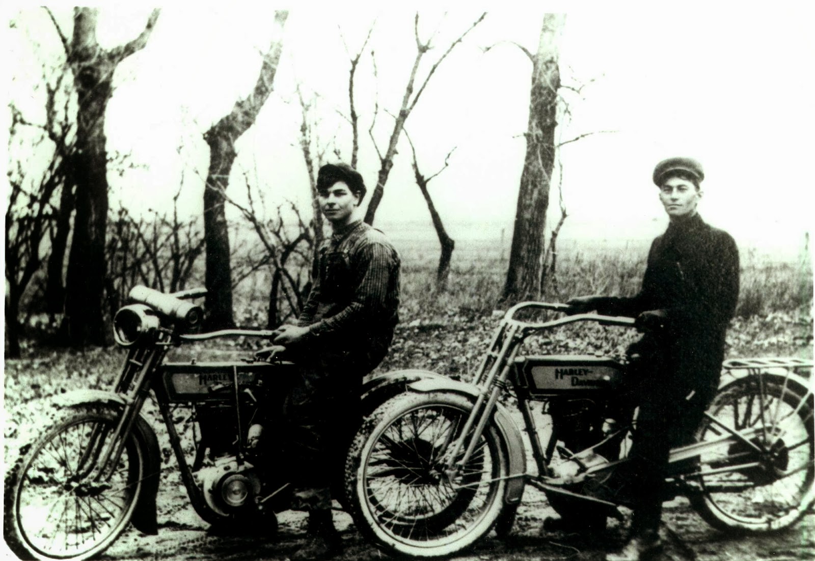
A few of the folks at the Unruh reunion had recently been to the Ostrog area in Ukraine and could attest to the fact that the inhabitants nowdays are poor and the land seems to be rather unproductive. I thoroughly enjoyed looking at their photos and hearing about their trip. Some German houses remain here and there in the area and an old-timer or two seem to remember some German names in the villages.
One of the grand-daughters of Jake Unruh (son of Benjamin Unruh) also had a German document which, after translating, was revealed to be a certificate attesting to the fact that Benjamin Unruh and his family were indeed Mennonites. The document is signed by the village minister, Johann Boese, who names the village as "Lilewa bei Ostrog' and the document was even stamped with the church's seal!

This Jake Unruh was also the man who penned the Leeleva map that is of such value today:

Although I wasn't directly related to the Unruhs at this reunion, I was probably related to everyone in the room in some way. After a bit of research, I found that I shared 3 sets of great-great-great grandparents with a few of the folks - I believe that makes me 4th cousins with them, 3 different ways! The Mennonites who lived in Leeleva in the early 20th Century were probably more like one big extended family and I'm sure my Ratzlaff ancestors would be happy to know that I attended the Unruh's reunion. Thanks again for welcoming me!
Friday, September 6, 2013
Cousin Gordon's blog; Leeleva Village Facebook page
Please check out Gordon Ratzloff's blog (Gordon is my 3rd cousin) at http://ceilingunlimited.com/fammail/
In the upcoming months we will have an interactive map of the village of Leeleva posted at this site where anyone can go to learn more about the elements of Jake Unruh's map of the village.
I've also started a Leeleva Village page on Facebook. It would be wonderful to create a virtual community where people could share family stories. If your ancestors lived in Leeleva (also known as Lisna, Lesna, Lebwa, Lesnaya, Lesnaja, Fuerstendorf, Fürstendorf, or Nikitskaya, please friend us (search for Leeleva Village Facebook to find the page).

In the upcoming months we will have an interactive map of the village of Leeleva posted at this site where anyone can go to learn more about the elements of Jake Unruh's map of the village.
I've also started a Leeleva Village page on Facebook. It would be wonderful to create a virtual community where people could share family stories. If your ancestors lived in Leeleva (also known as Lisna, Lesna, Lebwa, Lesnaya, Lesnaja, Fuerstendorf, Fürstendorf, or Nikitskaya, please friend us (search for Leeleva Village Facebook to find the page).

Wednesday, June 19, 2013
Ratsynskaya Forestry Camp
From about 1891 until the end of 1894, my Great-Grandfather,
Andreas Ratzlaff, was obliged by the Russian government to complete forestry
service in lieu of directly serving in the Russian military. According to Andreas' forestry service
discharge paperwork, he served at a camp named Ratsynskaya.
I'm not altogether sure where Ratzynskaya was. Mennonite sources do not indicate a camp by
this name. From the Mennonite Historical
Atlas, we find that there was a camp named Racyn. The name Racyn is close, but not quite what
the paperwork indicates.

From a map of the area north of Mikolaiv (Nikolayev) from the
early 1920s, we find a forest area labeled Rasinskaja Lessnaja-Deutsch; literally translated, that means Rasinskaya Forest-German. A forest area by the name of Rasinskaya that was associated with the Germans in some way.

Sources indicate that this forest was established in the 1870s; many different sorts of trees were planted at the location in an attempt to establish a wooded environment surrounding a natural ravine, just east of the Southern Bug River.
Today, this area is a small forest in the middle of south
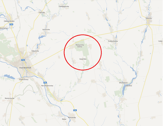
Ukraine called Рацинская (Ratsinskaya). It sits about 10 miles east of the town of Voznesens'k and serves as a nature reserve. The area is home to many types of wildlife and
plant-life. Could this be the Ratsinskaya
Forestry Camp where my Great-Grandfather Andreas Ratzlaff served in the 1890s?

Friday, April 26, 2013
Other Pluzhanskoy Villages
Other villages of interest in Pluzhanskoy included Boroisov, Bolotin, Balyary, Dertka, Miakoty,
Pivneva Gora, Mala (small) Radohosch, Storoniche (and Fuerstental/Kustarna), Gnoynitsa,
and Syvir.
Boroisov (Russian:
Борисов; Ukrainian: Borysiv, Бори́сів; Polish: Borisow; German: Borisoff), was
founded around the year 1520 and had close ties to the noble Ostrog Family
through the 16th and 17th Centuries. In 1618 the village was destroyed by Tatar
raiders. Boroisov was the center for the
local Orthodox Parish and a small green, wooden church with a gold onion dome
was built here. In the 19th
Century, this village had a Polish majority; by 1906 the population of the
village was 2899 people in 550 households.
After the Russian Revolution, Polish underground operations were
headquartered in the village as Boroisov was a center of resistance to Soviet
reforms. Local farmers used largely
passive means to oppose massive taxes.
Many chose to smuggle their goods across the border to sell in Poland
where they could get higher prices. Most
of the Polish population was evicted in the purges of the 1930s.
The village is about a mile or two due east of Pluzhnoe and
in 2001 had a population of about 1491 people.
Today the village administratively is in the Ukrainian Khmelnytsky Oblast or Province (Хмельницька область),
Izyaslav Raion or District (Ізяславському
районі), Borisov Village Rada or Council
(Борисівська сільська рада).
Bolotin (Russian:
Белотин; Ukrainian: Bilotyn, Біло́тин; Polish: Bialotyn; German: Belotin, also
known as Bielotyn), founded around the year 1506, is a village located along
the ancient road from Ostrog to Zaslaw.
For a couple decades in the mid-1800s, Bolotin was a resort town with natural
hydrogen sulfide baths. Bolotin was also
known in the 19th Century for its porcelain production due to nearby
deposits of white clay (kaolin). The
porcelain factory, which employed 89 people in 1867 and produced 23,000 pieces,
was Jewish owned. Red clay was found
later near Pivneva Gora, 3 miles away to the northwest, which enabled
production of flat red tiles. A
water-powered mill was located on the Rotten Horn River (Gnili Rig: Ukr: Гнили́й Ріг, Czarna; Pol: Gnily Row) which
flows through the town. In the late
1800s, a cholera epidemic swept through the village, resulting in many deaths which
effectively ended porcelain production.
By this time, Jews were 30% of the population while the majority was
Polish. In 1906 the village had a
population of 710 persons in 75 households.
The purges of the 1930s saw many Poles who were labeled Kulaks sent to Siberia. Just prior to WWII, the Soviets established a
concrete plant here and a temporary narrow gauge railway was built in 1946
which linked the town to Krivin. This
was dismantled only a year later. By the
mid 1900s, bus routes were established to Slavuta and Izyaslaw (Zaslaw). With the collapse of the USSR, schools, shops
and factories deteriorated. Today the
village is still in undergoing difficult times; most areas are covered with
weeds and the majority of the inhabitants are pensioners. The village is surrounded by the Ostrog
forest and most of the inhabitants (of whom there were 230 in 2001) make their
living from timber related industry.
Berries, mushrooms and herbs grow here, but the soil has never been
suitable for agriculture. By road via
Storoniche, the village lies about 7 miles northeast of Pluzhnoe. Today, the village administratively is in the
Ukrainian Khmelnytsky Oblast or Province
(Хмельницька область), Izyaslav Raion
or District (Ізяславському районі), Bilotinska Village Rada or Council (Білотинська сільська рада).
A firsthand account of a survivor of the Soviet purges of
the 20th century from the daughter of a villager of Bolotin can be
found here: http://sybir.blogspot.com/2005_09_28_archive.html
A mile straight east of Leeleva was the village of Khoten Druhyi or Second (II): (Russian: Хотень Второй or Другой; Ukrainian: Hoten
II, Хоте́нь Другий; Polish: Khoten
Druhyy; Germany Choten 2; also known as Balyary;
Баляри). This village, of unknown
establishment date, was in the 19th Century primarily inhabited by
Poles. The villagers worked in the
woods, toiling at forest-related industry including felling trees, sawing
boards, etc. These villagers established
a barrel-making industry producing staves and barrels in the 19th
and early 20th centuries (balyar
being a derivation of the Polish term for barrel) as the land surrounding
Balyary was not fit for farming. The
special axes that were required to make staves were made by the well-known local
blacksmith, Stephen Kosovo, or by the Germans in Karolswalde and Leeleva. In the 20th Century when demand
for barrels began to diminish, the villagers began to make a living fishing
from the nearby waterways. A small brook
(named Złuze) flowed between Khoten I and Balyary, narrow enough that a man
could jump over it. The water was pure
and clean. A mill was built at some
point in the early 1900s on this stream.
An elementary school was established in the village in the early 20th
Century, while the local secondary school (high school) was in Kunev. The Soviets established a professional agriculture
school here in mid-1930s. As with many
of the nearby villages, many Poles were evicted to the east in the 1930s. The village is in the Ukrainian Khmelnytsky Oblast or Province (Хмельницька область),
Izyaslav Raion or District (Ізяславському
районі), Pluzhnenska Village Rada or Council
(Плужненська сільська рада) and in 2001 had a population of 102 people. Khoten
Pershyi or First (I): (Russian: Хотень Первый; Ukrainian: Hoten
I, Хоте́нь Перший; Polish: Choten; German: Choten), is located ¼ mile east of
Balyary and had a population of 760 in 220 households in 1906. In 2001 this village had a population of 296.
Dertka (Russian:
Дертка; Ukrainian: Dertka, Де́ртка; Polish, German: Dertka), was populated by a
mix of Ukrainian and Polish inhabitants and was established in the 18th
Century. A late 19th Century Polish Gazetteer indicates that an extensive mill and sawmill, located on the pond, was located here, and that the inhabitants of the village busied themselves with sawing trees and producing tar. In 1906
the village had a population of 464 people living in 31 households. The Soviets established a concrete plant in
the village in the 1930s and in the 1960s Dertka was in the same collective as the
formerly German colonies of Novoselka (Jadwinin) and
Mikhaylovka. Residents today produce
vegetables such as corn, potatoes, beets, as well as hay. This village is just about a 1 ½ mile north
of Leeleva. In 2001 the village had a
population of 154 and today is in the Ukrainian Khmelnytsky Oblast or Province (Хмельницька область),
Izyaslav Raion or District (Ізяславському
районі), Dertkivska Village Rada or Council
(Дертківська сільська рада).
Miakoty (Russian:
Мякоты; Ukrainian: M’yakoti, М'яко́ти; Polish: Mjakoty; German: Miakoty) was
the site of a large dairy by the late 19th Century, and in 1906 the
village had a population of 1767 people in 329 households, most of whom were
Poles and Germans. The village neighbors
Leeleva immediately to the south, standing about a mile away. The population in 2001 was 1247 and today
Miakoty is in the Ukrainian Khmelnytsky Oblast
or Province (Хмельницька область), Izyaslav Raion
or District (Ізяславському районі), M’yakotivska Village Rada or Council (М'якотівська сільська рада).
Pivneva Gora (Pivneva
Mount) (Russian: Пивнева Гора; Ukrainian: Pivneva Hora; Пі́внева Го́ра;
Polish: Pivneva Hora) is a village named for a Jewish innkeeper named Pinya,
who established an inn at this location on hills in the Ostrog forest about 3
miles northeast of Mikhaylovka. In the
19th Century, clay was exported from this village to locations
including Ostrog in order to make pottery.
In 1906, the population was only 10 people in 2 households. Today, Pivneva Gora stands on the southern
shores of the cooling reservoir for the nuclear plant in Netishyn. Today the village is a near ghost-town as
people have moved to more urbanized areas.
The population in 2001 was only 7 people. The village administratively is in the Ukrainian
Khmelnytsky Oblast or Province (Хмельницька
область), Izyaslav Raion or District (Ізяславському
районі), Bilotinska Village Rada or Council
(Білотинська сільська рада).
Mala (small) Radogosch
(Russian: Малая Радогощь; Ukrainian: Mala Radohosch, Мала́ Радогощ; Polish:
Mała Radohoszcz; German: Klein Radogoschtsch) was first mentioned in the
village’s charter of 1396, when the village was given to the reigning Ostrohski
prince from the Grand Duke of Lithuania.
By the 19th Century, the population of the village was mostly
Polish and contained Roman Catholic as well as Russian Orthodox
congregations. Some Ukrainian Catholics also
lived in this village. A wooden church,
the Orthodox Pokrovska Tservka
(Intercession Church) was built in the village in the second half of the 19th
Century. In 1906, the population of this
village was 237 people in 43 households.
As with other Polish villages, many inhabitants were
expelled by the Soviets in the 1930s.
Some of these Polish villages tried to retain their Polish culture
during the ‘20s and early ‘30s, but all eventually succumbed to Stalin’s forces
by the mid-1930s. Small Radogosch is the
neighboring village to Leeleva immediately to the west, sitting just 1 mile
away. Only ¼ mile to the west is the
village named Velyka (great) Radogosch.
In 2001 the population was 124 people.
Today the village is in the Ukrainian Khmelnytsky Oblast or Province (Хмельницька область), Izyaslav Raion or District (Ізяславському районі),
M’yakotivska Village Rada or Council (М'якотівська
сільська рада).
Storoniche
(Russian: Сторониче; Ukrainian: Storonyche, Сторони́че; Polish: Storonicze;
German: Storonitsche) is a village which was founded around 1803 on land owned
by the Jablonovsky Family. Storoniche
remained under Jablonovsky possession until the Russian Civil War. The village stands in the middle of the
Ostrog Forest, on the northern edge of a large swamp. In 1906, the population of the village was 323
people in 51 households.
In the 1920s a large percentage of the population of
Storoniche was Polish, and the villagers fought to keep Polish culture intact. Most of the Poles were evicted, however, in
the 1930s. Today there is a woodworking
plant just to the east of the village and a national park is planned to be
built southeast of the town (Small Polesie).
The population of the village in 2010 was just 80 people and it is in
the Ukrainian Khmelnytsky Oblast or Province
(Хмельницька область), Izyaslav Raion
or District (Ізяславському районі), Borisov Village Rada or Council (Борисівська сільська рада).
Storoniche is located about 2 miles southeast of Mikhaylovka
and directly south of the village in the 19th Century stood the
German colony of Kustarna (Russian:
Кустарна; Ukrainian: Кустарне; also known as Kustarnaja; German: Fuerstenthal [Ru, Ukr: Фюрштенталь],
also known as Fuerstental or Fürstenthal).
Extinct today, Fuerstenthal was established at some point before
1874. Initially, the village was predominantly
German Mennonite but later came to be populated largely by German
Lutherans. The Lutheran Church at Fuerstenthal
fell into the Rivne Lutheran Parish. The
site of the village was approximately at 50°13’05.6”N, 26°36’30.8”E, where it
practically adjoined Storoniche. Soviet
maps from the 1940s no longer show this village, but in 1906 the population was
236 people in 42 households.
The village of Syver:
(Russian: Cивер; Ukrainian: Syvir, Си́вір; Polish: Syvir, Siewierz;
German: Ssiwer, also known as Siwerka) was established in 1834 and practically
adjoins Leeleva to the north. The village
sat on the edge of a small lake along the Riska River (Gutiska; Hutyska?). In the 19th Century a mill was located
in this village on the pond which was drained sometime during the 1930s or
1940s. Some accounts indicate that Syver
and Leeleva were actually the same village during the 19th Century
but maps from that time show them to be two separate communities. In 1906 the population of the village was 214
in 21 households. In 2001, the
population was 151. The village today is
in the Ukrainian Khmelnytsky Oblast
or Province (Хмельницька область), Izyaslav Raion
or District (Ізяславському районі), Dertkivska Village Rada or Council (Дертківська сільська рада).
Gnoynitsa (Ru: Гнойница
or Гнийниця or [Velikya] Великая Гнийниця; Ukr: Gniynitsya, Гнойніца, Гнійниця,
or Велика [Velika] Гнійниця; Polish: Wielki Hniynytsya; German: [Bol.]
Gnojnica) is an ancient village founded as early as 1152. In 1906 the population of this village was
1010 in 191 households. The village’s
name was changed by the Soviets in 1944 to Polesskiy (Полесский; Ukr: Poliske,
Полі́ське). This village is practically
due south of Pluzhnoe almost 5 miles. In 2001 the population was 704 people and
it is in Ukrainian Khmelnytsky Oblast
or Province (Хмельницька область), Izyaslav Raion
or District (Ізяславському районі),
Poliska Village Rada
or Council (Поліська сільська рада)
Subscribe to:
Posts (Atom)