Sunday, September 22, 2013

Unruh Family Reunion, 2013

I would like to thank the Benjamin Unruh Family for graciously welcoming me to their family reunion which took place a couple weeks ago in Halstead, KS.  I found out the reunion was to take place, contacted a couple folks who were hosting, and they very warmly invited me to attend.

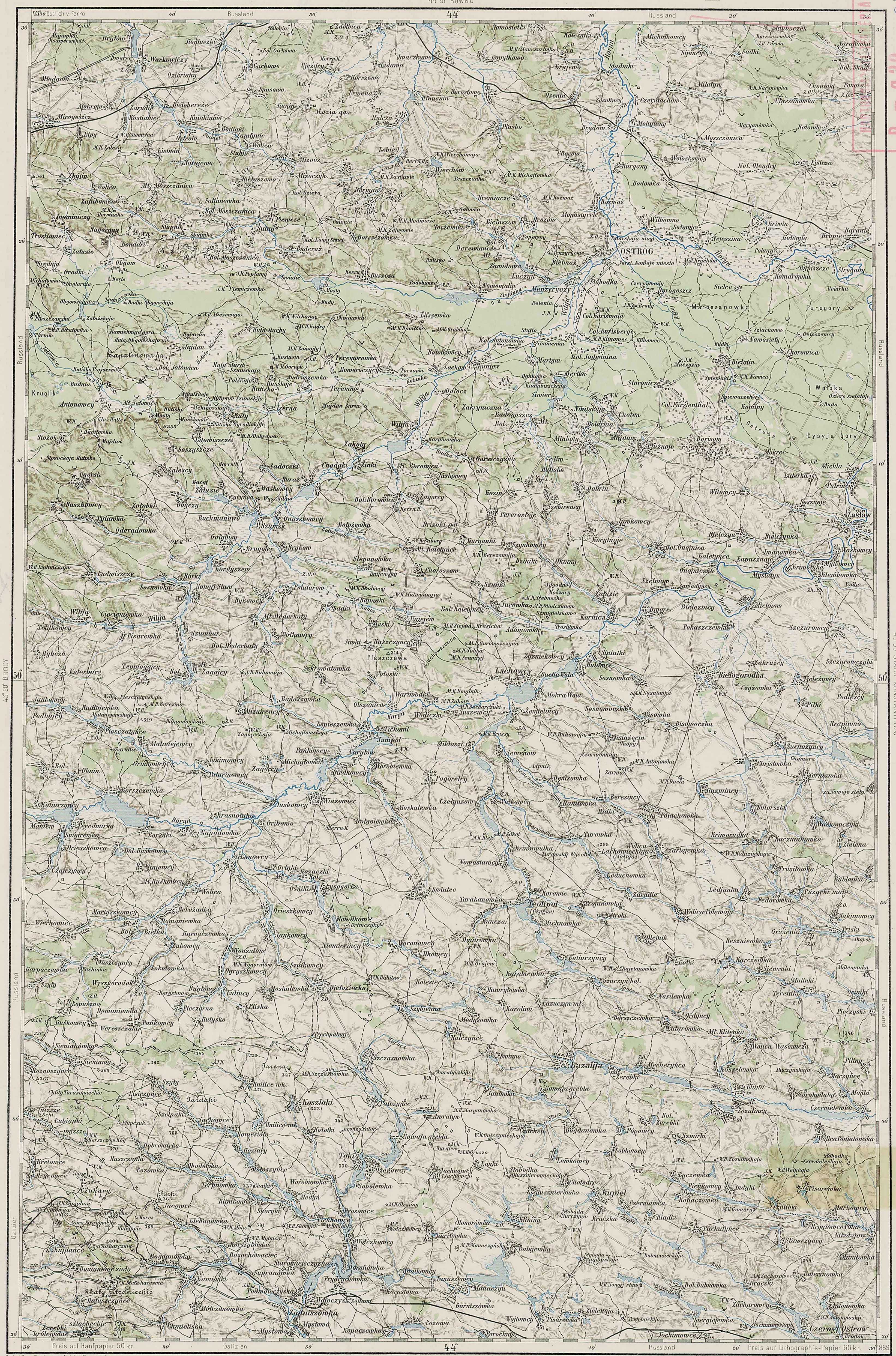
This Benjamin Unruh was the head of the family which accompanied my Ratzlaff and Wedel families to USA in 1907.  Benjamin was actually related to the Wedel family too, so all 3 of these families were inter-related.  I'm assuming that Benjamin was also a good friend of my great-grandfather Andreas' oldest brother Henry J. Ratzloff since they were both born in the same year.  This photo, on display at the Unruh reunion, and given to me by my 3rd cousin Gordon Ratzloff, shows Henry Ratzloff's son, Jonas, along with Benjamin Unruh's oldest son Jake, on their motorcycles in 1913 (that's Jonas on the left and Jake on the right):


A few of the folks at the Unruh reunion had recently been to the Ostrog area in Ukraine and could attest to the fact that the inhabitants nowdays are poor and the land seems to be rather unproductive.  I thoroughly enjoyed looking at their photos and hearing about their trip.  Some German houses remain here and there in the area and an old-timer or two seem to remember some German names in the villages.

One of the grand-daughters of Jake Unruh (son of Benjamin Unruh) also had a German document which, after translating, was revealed to be a certificate attesting to the fact that Benjamin Unruh and his family were indeed Mennonites.  The document is signed by the village minister, Johann Boese, who names the village as "Lilewa bei Ostrog' and the document was even stamped with the church's seal!


This Jake Unruh was also the man who penned the Leeleva map that is of such value today:


Although I wasn't directly related to the Unruhs at this reunion, I was probably related to everyone in the room in some way.  After a bit of research, I found that I shared 3 sets of great-great-great grandparents with a few of the folks - I believe that makes me 4th cousins with them, 3 different ways!  The Mennonites who lived in Leeleva in the early 20th Century were probably more like one big extended family and I'm sure my Ratzlaff ancestors would be happy to know that I attended the Unruh's reunion.  Thanks again for welcoming me!

Friday, September 6, 2013

Cousin Gordon's blog; Leeleva Village Facebook page

Please check out Gordon Ratzloff's blog (Gordon is my 3rd cousin) at http://ceilingunlimited.com/fammail/

In the upcoming months we will have an interactive map of the village of Leeleva posted at this site where anyone can go to learn more about the elements of Jake Unruh's map of the village.


I've also started a Leeleva Village page on Facebook.  It would be wonderful to create a virtual community where people could share family stories.  If your ancestors lived in Leeleva (also known as Lisna, Lesna, Lebwa, Lesnaya, Lesnaja, Fuerstendorf, Fürstendorf, or Nikitskaya, please friend us (search for Leeleva Village Facebook to find the page).


Wednesday, June 19, 2013

Ratsynskaya Forestry Camp

From about 1891 until the end of 1894, my Great-Grandfather, Andreas Ratzlaff, was obliged by the Russian government to complete forestry service in lieu of directly serving in the Russian military.  According to Andreas' forestry service discharge paperwork, he served at a camp named Ratsynskaya. 

I'm not altogether sure where Ratzynskaya was.  Mennonite sources do not indicate a camp by this name.  From the Mennonite Historical Atlas, we find that there was a camp named Racyn.  The name Racyn is close, but not quite what the paperwork indicates.


From a map of the area north of Mikolaiv (Nikolayev) from the early 1920s, we find a forest area labeled Rasinskaja Lessnaja-Deutsch;  literally translated, that means Rasinskaya Forest-German.  A forest area by the name of Rasinskaya that was associated with the Germans in some way.


Sources indicate that this forest was established in the 1870s; many different sorts of trees were planted at the location in an attempt to establish a wooded environment surrounding a natural ravine, just east of the Southern Bug River.


Today, this area is a small forest in the middle of south Ukraine called Рацинская (Ratsinskaya).  It sits about 10 miles east of the town of Voznesens'k and serves as a nature reserve.  The area is home to many types of wildlife and plant-life.  Could this be the Ratsinskaya Forestry Camp where my Great-Grandfather Andreas Ratzlaff served in the 1890s?


Friday, April 26, 2013

Other Pluzhanskoy Villages


Other villages of interest in Pluzhanskoy included Boroisov, Bolotin, Balyary, Dertka, Miakoty, Pivneva Gora, Mala (small) Radohosch, Storoniche (and Fuerstental/Kustarna), Gnoynitsa, and Syvir.

Boroisov (Russian: Борисов; Ukrainian: Borysiv, Бори́сів; Polish: Borisow; German: Borisoff), was founded around the year 1520 and had close ties to the noble Ostrog Family through the 16th and 17th Centuries.  In 1618 the village was destroyed by Tatar raiders.  Boroisov was the center for the local Orthodox Parish and a small green, wooden church with a gold onion dome was built here.  In the 19th Century, this village had a Polish majority; by 1906 the population of the village was 2899 people in 550 households.  After the Russian Revolution, Polish underground operations were headquartered in the village as Boroisov was a center of resistance to Soviet reforms.  Local farmers used largely passive means to oppose massive taxes.  Many chose to smuggle their goods across the border to sell in Poland where they could get higher prices.  Most of the Polish population was evicted in the purges of the 1930s. 

The village is about a mile or two due east of Pluzhnoe and in 2001 had a population of about 1491 people.  Today the village administratively is in the Ukrainian Khmelnytsky Oblast or Province (Хмельницька область), Izyaslav Raion or District (Ізяславському районі), Borisov Village Rada or Council (Борисівська сільська рада).


Bolotin (Russian: Белотин; Ukrainian: Bilotyn, Біло́тин; Polish: Bialotyn; German: Belotin, also known as Bielotyn), founded around the year 1506, is a village located along the ancient road from Ostrog to Zaslaw.  For a couple decades in the mid-1800s, Bolotin was a resort town with natural hydrogen sulfide baths.  Bolotin was also known in the 19th Century for its porcelain production due to nearby deposits of white clay (kaolin).  The porcelain factory, which employed 89 people in 1867 and produced 23,000 pieces, was Jewish owned.  Red clay was found later near Pivneva Gora, 3 miles away to the northwest, which enabled production of flat red tiles.  A water-powered mill was located on the Rotten Horn River (Gnili Rig: Ukr: Гнили́й Ріг, Czarna; Pol: Gnily Row) which flows through the town.  In the late 1800s, a cholera epidemic swept through the village, resulting in many deaths which effectively ended porcelain production.  By this time, Jews were 30% of the population while the majority was Polish.  In 1906 the village had a population of 710 persons in 75 households. 

The purges of the 1930s saw many Poles who were labeled Kulaks sent to Siberia.  Just prior to WWII, the Soviets established a concrete plant here and a temporary narrow gauge railway was built in 1946 which linked the town to Krivin.  This was dismantled only a year later.  By the mid 1900s, bus routes were established to Slavuta and Izyaslaw (Zaslaw).  With the collapse of the USSR, schools, shops and factories deteriorated.  Today the village is still in undergoing difficult times; most areas are covered with weeds and the majority of the inhabitants are pensioners.  The village is surrounded by the Ostrog forest and most of the inhabitants (of whom there were 230 in 2001) make their living from timber related industry.  Berries, mushrooms and herbs grow here, but the soil has never been suitable for agriculture.  By road via Storoniche, the village lies about 7 miles northeast of Pluzhnoe.  Today, the village administratively is in the Ukrainian Khmelnytsky Oblast or Province (Хмельницька область), Izyaslav Raion or District (Ізяславському районі), Bilotinska Village Rada or Council (Білотинська сільська рада).

A firsthand account of a survivor of the Soviet purges of the 20th century from the daughter of a villager of Bolotin can be found here: http://sybir.blogspot.com/2005_09_28_archive.html


A mile straight east of Leeleva was the village of Khoten Druhyi or Second (II): (Russian: Хотень Второй or Другой; Ukrainian: Hoten II, Хоте́нь Другий; Polish: Khoten Druhyy; Germany Choten 2; also known as Balyary; Баляри).  This village, of unknown establishment date, was in the 19th Century primarily inhabited by Poles.  The villagers worked in the woods, toiling at forest-related industry including felling trees, sawing boards, etc.  These villagers established a barrel-making industry producing staves and barrels in the 19th and early 20th centuries (balyar being a derivation of the Polish term for barrel) as the land surrounding Balyary was not fit for farming.  The special axes that were required to make staves were made by the well-known local blacksmith, Stephen Kosovo, or by the Germans in Karolswalde and Leeleva.  In the 20th Century when demand for barrels began to diminish, the villagers began to make a living fishing from the nearby waterways.  A small brook (named Złuze) flowed between Khoten I and Balyary, narrow enough that a man could jump over it.  The water was pure and clean.  A mill was built at some point in the early 1900s on this stream.  An elementary school was established in the village in the early 20th Century, while the local secondary school (high school) was in Kunev.  The Soviets established a professional agriculture school here in mid-1930s.  As with many of the nearby villages, many Poles were evicted to the east in the 1930s.  The village is in the Ukrainian Khmelnytsky Oblast or Province (Хмельницька область), Izyaslav Raion or District (Ізяславському районі), Pluzhnenska Village Rada or Council (Плужненська сільська рада) and in 2001 had a population of 102 people.  Khoten Pershyi or First (I): (Russian: Хотень Первый; Ukrainian: Hoten I, Хоте́нь Перший; Polish: Choten; German: Choten), is located ¼ mile east of Balyary and had a population of 760 in 220 households in 1906.  In 2001 this village had a population of 296.


Dertka (Russian: Дертка; Ukrainian: Dertka, Де́ртка; Polish, German: Dertka), was populated by a mix of Ukrainian and Polish inhabitants and was established in the 18th Century.  A late 19th Century Polish Gazetteer indicates that an extensive mill and sawmill, located on the pond, was located here, and that the inhabitants of the village busied themselves with sawing trees and producing tar.  In 1906 the village had a population of 464 people living in 31 households.  The Soviets established a concrete plant in the village in the 1930s and in the 1960s Dertka was in the same collective as the formerly German colonies of Novoselka (Jadwinin) and Mikhaylovka.  Residents today produce vegetables such as corn, potatoes, beets, as well as hay.  This village is just about a 1 ½ mile north of Leeleva.  In 2001 the village had a population of 154 and today is in the Ukrainian Khmelnytsky Oblast or Province (Хмельницька область), Izyaslav Raion or District (Ізяславському районі), Dertkivska Village Rada or Council (Дертківська сільська рада).


Miakoty (Russian: Мякоты; Ukrainian: M’yakoti, М'яко́ти; Polish: Mjakoty; German: Miakoty) was the site of a large dairy by the late 19th Century, and in 1906 the village had a population of 1767 people in 329 households, most of whom were Poles and Germans.  The village neighbors Leeleva immediately to the south, standing about a mile away.  The population in 2001 was 1247 and today Miakoty is in the Ukrainian Khmelnytsky Oblast or Province (Хмельницька область), Izyaslav Raion or District (Ізяславському районі), M’yakotivska Village Rada or Council (М'якотівська сільська рада).


Pivneva Gora (Pivneva Mount) (Russian: Пивнева Гора; Ukrainian: Pivneva Hora; Пі́внева Го́ра; Polish: Pivneva Hora) is a village named for a Jewish innkeeper named Pinya, who established an inn at this location on hills in the Ostrog forest about 3 miles northeast of Mikhaylovka.  In the 19th Century, clay was exported from this village to locations including Ostrog in order to make pottery.  In 1906, the population was only 10 people in 2 households.  Today, Pivneva Gora stands on the southern shores of the cooling reservoir for the nuclear plant in Netishyn.  Today the village is a near ghost-town as people have moved to more urbanized areas.  The population in 2001 was only 7 people.  The village administratively is in the Ukrainian Khmelnytsky Oblast or Province (Хмельницька область), Izyaslav Raion or District (Ізяславському районі), Bilotinska Village Rada or Council (Білотинська сільська рада).


Mala (small) Radogosch (Russian: Малая Радогощь; Ukrainian: Mala Radohosch, Мала́ Радогощ; Polish: Mała Radohoszcz; German: Klein Radogoschtsch) was first mentioned in the village’s charter of 1396, when the village was given to the reigning Ostrohski prince from the Grand Duke of Lithuania.  By the 19th Century, the population of the village was mostly Polish and contained Roman Catholic as well as Russian Orthodox congregations.  Some Ukrainian Catholics also lived in this village.  A wooden church, the Orthodox Pokrovska Tservka (Intercession Church) was built in the village in the second half of the 19th Century.  In 1906, the population of this village was 237 people in 43 households.

As with other Polish villages, many inhabitants were expelled by the Soviets in the 1930s.  Some of these Polish villages tried to retain their Polish culture during the ‘20s and early ‘30s, but all eventually succumbed to Stalin’s forces by the mid-1930s.  Small Radogosch is the neighboring village to Leeleva immediately to the west, sitting just 1 mile away.  Only ¼ mile to the west is the village named Velyka (great) Radogosch.  In 2001 the population was 124 people.  Today the village is in the Ukrainian Khmelnytsky Oblast or Province (Хмельницька область), Izyaslav Raion or District (Ізяславському районі), M’yakotivska Village Rada or Council (М'якотівська сільська рада).


Storoniche (Russian: Сторониче; Ukrainian: Storonyche, Сторони́че; Polish: Storonicze; German: Storonitsche) is a village which was founded around 1803 on land owned by the Jablonovsky Family.  Storoniche remained under Jablonovsky possession until the Russian Civil War.  The village stands in the middle of the Ostrog Forest, on the northern edge of a large swamp.  In 1906, the population of the village was 323 people in 51 households.

In the 1920s a large percentage of the population of Storoniche was Polish, and the villagers fought to keep Polish culture intact.  Most of the Poles were evicted, however, in the 1930s.  Today there is a woodworking plant just to the east of the village and a national park is planned to be built southeast of the town (Small Polesie).  The population of the village in 2010 was just 80 people and it is in the Ukrainian Khmelnytsky Oblast or Province (Хмельницька область), Izyaslav Raion or District (Ізяславському районі), Borisov Village Rada or Council (Борисівська сільська рада).

Storoniche is located about 2 miles southeast of Mikhaylovka and directly south of the village in the 19th Century stood the German colony of Kustarna (Russian: Кустарна; Ukrainian: Кустарне; also known as Kustarnaja; German: Fuerstenthal [Ru, Ukr: Фюрштенталь], also known as Fuerstental or Fürstenthal).  Extinct today, Fuerstenthal was established at some point before 1874.  Initially, the village was predominantly German Mennonite but later came to be populated largely by German Lutherans.  The Lutheran Church at Fuerstenthal fell into the Rivne Lutheran Parish.  The site of the village was approximately at 50°13’05.6”N, 26°36’30.8”E, where it practically adjoined Storoniche.  Soviet maps from the 1940s no longer show this village, but in 1906 the population was 236 people in 42 households.


The village of Syver: (Russian: Cивер; Ukrainian: Syvir, Си́вір; Polish: Syvir, Siewierz; German: Ssiwer, also known as Siwerka) was established in 1834 and practically adjoins Leeleva to the north.  The village sat on the edge of a small lake along the Riska River (Gutiska; Hutyska?).  In the 19th Century a mill was located in this village on the pond which was drained sometime during the 1930s or 1940s.  Some accounts indicate that Syver and Leeleva were actually the same village during the 19th Century but maps from that time show them to be two separate communities.  In 1906 the population of the village was 214 in 21 households.  In 2001, the population was 151.  The village today is in the Ukrainian Khmelnytsky Oblast or Province (Хмельницька область), Izyaslav Raion or District (Ізяславському районі), Dertkivska Village Rada or Council (Дертківська сільська рада).


Gnoynitsa (Ru: Гнойница or Гнийниця or [Velikya] Великая Гнийниця; Ukr: Gniynitsya, Гнойніца, Гнійниця, or Велика [Velika] Гнійниця; Polish: Wielki Hniynytsya; German: [Bol.] Gnojnica) is an ancient village founded as early as 1152.  In 1906 the population of this village was 1010 in 191 households.  The village’s name was changed by the Soviets in 1944 to Polesskiy (Полесский; Ukr: Poliske, Полі́ське).  This village is practically due south of Pluzhnoe almost 5 miles. In 2001 the population was 704 people and it is in Ukrainian Khmelnytsky Oblast or Province (Хмельницька область), Izyaslav Raion or District (Ізяславському районі),
Poliska Village Rada or Council (Поліська сільська рада)


Tuesday, April 23, 2013

The Village of Leeleva


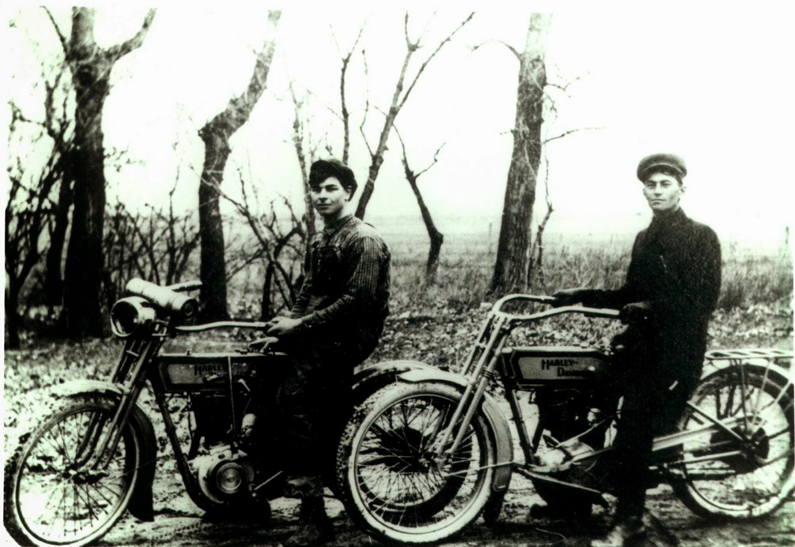
The village of Leeleva was located on the main road that ran from Kamenka to Pluzhnoe.  Travelling generally south-southeast, one would have passed out of Kamenka, through the forest, over a couple large hills and then downhill into Dertka.  From there, the road went again straight south, over a large hill, and down into Siver.  This stretch of road passed between two small lakes which were drained probably in the 1940s.  Leeleva lay just south of Siver, at an elevation of about 210 meters.  The main road through the village went generally uphill and continued on to Miakoty, less than a mile to the south, which is at an elevation of about 220 meters.  This road continued on to Pluzhnoe, another 3 miles farther east. Two hills rise just to the south of the houses of Leeleva, the taller of which rises over 240 meters.  The distance by road from Kamenka to Leeleva was almost 4 miles and in the 19th Century would have been almost entirely through forest.  The main road through Leeleva ran northwest to southeast.  Another east-west road ran through the village; west to Mala (small) Radogosch and east to Balyary.  Some researchers seem to have combined Leeleva with Siver; this appears to be incorrect.  Based on current satellite views as well as old Polish, Russian and Austrian maps, Siver (today known as Syvir; Ukr: Сйвір) is a separate village immediately adjacent to Leeleva to the northwest.  

German: Fuerstendorf or Fürstendorf (Russian: Фюрштендорф; Ukrainian: Фюрштендорф),

Russian: Lesna: (Ru: Лесна or Лѣснa; Ukr: Lisna, Лісна; Polish: Lisna),

Also known as Lesnaja (Ru: Лѣсная or Лесная; Ukr: Лiсня), or Liesnaja or Lesnaya,

Leeleva (Ru: Лелева; Ukr: Лелевой) or Lileva or Lilewa,

Also known as Lebwa, Nikitskaya or Nikitska. 

There may be confusion about the name of this village as lesna/lisna is a term for “forest” in Russian and Ukrainian.  Further, the forest south of Ostrog may have been named Nikitskaya Forest at some point in time.  German-speaking cartographers of the late 19th Century may have confused the village and the forest and mistakenly labeled the village Nikitskaya instead of the forest (Jewish sources name a forest near Ostrog Nikitsky or Nikitin).

Established as early as 1765 by Ukrainians or Poles, the earliest appearance of the village in Mennonite sources (under its German name: Fuerstendorf) is 1874.   My Ratzlaff Family tradition suggests that Ratzlaffs lived in this village, which they called Leeleva, by 1869. 

This village was the last home of the Mennonite colonists in the Ostrog area.  As the majority of Mennonites left the other nearby villages in the last quarter of the 18th Century, those who stayed behind consolidated in Leeleva.  German Lutheran colonists began moving into the village as the Mennonites left for America.  The Lutheran Church fell under the authority of the Rivne Lutheran Parish.  Early 20th century Mennonite sources state the Mennonite Church in Leeleva was affiliated with the (Neu) Alexanderwohl Mennonite congregation, which suggests a connection between this village and Polish (Royal Prussian) Przechowka.  A 1930s map of Lutheran Leeleva indicates that the area to the east of the village was used as communal meadow.  A road to the west of the village, Teppergasse, seems to indicate the presence of a tavern or a brewery/distillery of some sort while the road to the east, Entenquak, suggests a duckfarm or something similar.  The Lutheran map goes on to indicate the cemetery on the west side of the road, mid-way through the village, with the church directly across the street to the east.  My own Ratzlaff Family tradition indicates the houses in the village were offset one from another in order to prevent fires spreading from one yard to another.

A 1906 census of the region included a village by the name of Lesnaya (Лѣсня) as well as one by the name of Leleva (Лелева).  The population of Lesnaya was listed as 267 in 52 households and Leleva as 244 in 26 households.  Both were listed as falling under the jurisdiction of the 3rd police precinct of Ostrog County.  At this point I have no idea why 2 villages were listed in this census.

The German inhabitants of the village were known as skilled farmers and blacksmiths.  From at least 1889, as indicated by an Austrian map of that date, these farmers may have taken their grain to be milled at a watermill located at nearby Siver.  If, that is, the landlords of the tenant farmers allowed it.  After the Russian Revolution, the council of the village continued to use the German language until the 1930s, but most Germans were evicted by the year 1936 (30 German and Polish families were evicted at this time, perhaps to Kazakhstan).  Leeleva was placed by the Soviets in the collective which included Dertka, Siver, Jadvanin, and Mikhaylovka. 

In 2001, the population of the village was 97 people.  The village today is in the Ukrainian Khmelnytsky Oblast or Province (Хмельницька область), Izyaslav Raion or District (Ізяславському районі), Dertkivska Village Rada or Council (Дертківська сільська рада).


Green Ratzlaff Book

Abe Unruh, The Helpless Poles

Lutheran Lesnaya map

Mennonite Leeleva map

Friday, April 19, 2013

The Villages of Mikhaylovka and Stanislavka


The village of Mikhaylovka sat less than a mile southeast of Jadwinin (almost 2 miles by road via Klinowiec).  In the 19th Century, one would have left Jadwinin to the east and gone about ½ mile to Klinowiec (also known as Borisovskoye-Klinovets) which sat at the base of a small hill.  The road went around the hill and turned south through the forest and entered Mikhaylovka in about a mile.  The village was situated in an east-west orientation at an elevation of about 210 meters; rising slightly in the middle and downhill on both ends.

Known as Mikhaylovka in Russian (Михайловка or Михайлівка; Ukrainian: Mykhailivka, Миха́йлівка; Polish: Mykhajlivka; German: Michajlowka, Michailowka), the village was founded at an unknown date after 1874 by Germans, either Mennonites or Lutherans, on a small stream called the Dreloh (now called Synytseva).  The German inhabitants specialized in agriculture and grew rye, potatoes, barley, millet and buckwheat.  During the 19th Century, grain was transported to the mill at Ostrog for harvesting.  After the Polish War in 1921, grain was taken to mill in Slavuta as Ostrog became a Polish town.  Villagers during this time also raised some cows and pigs as well.

By the late 1800s, Mikhaylovka consisted of 35 houses with some 241 inhabitants.  Houses were built with pine boards which were joined at the corners with “fishtail” joints.  Wealthy inhabitants bought cut foundation stones from Kamenka to create a foundation and floor for their homes.  Less wealthy folks had to make due with foundation stones only at the corners or under door jambs of their houses.  Most houses had large stoves, built with raw bricks covered with plaster.  Bricks were made from clay from nearby clay deposits.  A house dating from the late 1880s reportedly still stands in the village today.  Grain was usually threshed with flails, while a few more wealthy farmers could afford a horsedrawn threshing wheel.  Later in the 19th Century, grain was also taken to mills that had been erected nearby in the villages of Nitishin, Bolotin, Kamenka, Dertka, or Balyary.  The villagers in Mikhaylovka attempted to build a mill, but unfortunately were not successful.

In 1906 the population of the village was 264 people living in 48 households.  As with the other nearby villages, Mikhaylovka underwent forced collectivization during the 1920s and in 1936 was placed into a collective with the other remaining German villages of Leeleva (Lesna) and Karolswalde.  Later the collective removed Karolswalde and added Jadwanin and Dertka.  Some Poles and Czechs moved into the village during this time.  During collectivization, the Mikhaylovka wooden church was closed down by the Soviets and many Germans were evicted to Siberia.  In 1939 German villagers from nearby Stanislovka were relocated to Mikhaylovka.  Then in 1942, any remaining Germans were relocated to a village near Yuvkivtsi (about 8.5 miles to the south) forming the village of Zonental (Sun Valley).  The primary school in the village was also closed by the Soviets at some point by the 1960s.

Since Mikhaylovka was originally a German village, the cemetery held only Germans.  Later, as Poles or Czechs moved into the village, they had to be buried elsewhere, such as Jadwinin or Kunev.  After WWII, with the eviction of the Germans, the village was populated predominantly by descendents of Poles.  However, a woman named Tatiana Nightengale, perhaps a descendent of the German Mennonites, was still listed as a school teacher in the village in the mid 1940s.

Today, the results of the collapse of the USSR and the rise of a capitalist economy have almost destroyed the village, leaving it populated mostly by pensioners; the population in 2001 was only 58 people.  The village is presently in the Ukrainian Khmelnytsky Oblast or Province (Хмельницька область), Izyaslav Raion or District (Ізяславському районі), Dertkivska Village Rada or Council (Дертківська сільська рада).


http://istvolyn.info/index.php?option=com_content&task=view&id=926&Itemid=5


The German village of Stanislavka (Russian: Станіславка; Ukrainian: Станіславка; Stanislavka; also known as Stanisovka) sat just to the southwest of Mikhaylovka.  The village was situated in a north-south orientation along the road running from Mikhaylovka to Balyary and Khoten.  Leaving Mikhaylovka to the west, one would have turned south after about ¼ mile.  The road gently curved uphill to the east and in slightly less than a mile, one would have reached Stanislavka.

Today the village of Stanislavka no longer exists.  Along with Mikhaylovka, it was established after 1874 by German Mennonites or Lutherans.  Austrian maps from the late 1880s show neither Mikhaylovka nor Stanislavka, but Polish maps from several years later do indeed show both villages.  In 1906 the village had a population of 461 people in 46 households.  However, the village disappeared soon after 1939 when the Soviets moved the German population to nearby Mikhaylovka.  The site of the village was at approximately 50°13’55.4”N, 26°30’22.7”E.


Thursday, April 18, 2013

FM Goossen Family

One of the most interesting things about posting a family history blog is meeting distant family members who are also interested in the family history.  I've been contacted by numerous Ratzlaffs, to whom many I can easily trace my relationship.

Recently I was contacted by a grand-daughter of Florentine (Ratzlaff) Goossen.  Florentine was born in Leeleva, Volhynia, in 1904, to Andreas and Susanna (Wedel) Ratzlaff and was an older sister to my grandfather, Albert Ratzlaff.  Florentine married John D Goossen, son of Franz Goossen (FM for short) of Marion County, KS, in 1924 at the Alexanderwohl Mennonite Church and the family made their home a mile south and about 5 miles east of Hillsboro, in Wilson Township.  Florentine and John had 7 children who were cousins to my father, Norman Ratzlaff, and I think my Dad palled around with these Goossen boys quite a bit when they were young.  Dad has told me numerous stories about this family's adventures; most of the sons were involved with motorcycles, airplanes, etc, and as I understand it, one of them even busied himself by prospecting for gold in the mountains of the western United States!  Several of the boys moved to Farmington, New Mexico, when they grew up.

The Goossen family was among the Russian Mennonites emigrating to the US from the Molotschna Colony.  The Goossens traveled to the United States aboard the SS Vaderland in 1877 (the same steamship that brought my great great great grandmother Anna (Koehn) Ratzlaff to America in 1874 as well as my great great grandfather Heinrich Wiens in 1876).  Much more can be learned about the Franz Goossen Family at http://www.fmgoossenfamily.com/WP/.